March 17, 2016
New CRISM Data Products Offer Greater Accessibility to Mars Researchers
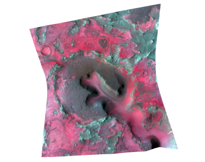
This observation of the Nili Fossae region (FRT00003E12) was acquired by CRISM on January 13, 2007, and shows a variety of rock types including basaltic rock in gray, igneous rock rich in the mineral olivine in magenta, clay-rich rock in blue-gray, and small carbonate-rich outcrops in green. All of the advanced processing steps have been applied to this image to remove effects of the atmosphere and instrument artifacts. The hour-glass shape of the image results from the changing range to the target point on Mars' surface as the image was taken over nearly 3 minutes.
Since it began operations in 2006, the Compact Reconnaissance Imaging Spectrometer for Mars (CRISM) instrument on board NASA’s Mars Reconnaissance Orbiter (MRO) has contributed to some of the most important findings about the past and present climate of the Red Planet. To do that, CRISM has acquired tens of thousands of targeted observations that each sample hundreds of visible and near-infrared wavelengths needed to map the wide range of minerals now known to occur on Mars. CRISM’s targeted, high-resolution, hyperspectral data allow scientists to investigate Mars’ surface mineralogy at an unprecedented spatial scale of 20 meters (66 feet) per pixel.
However, use of the data by the scientific community to study the Martian surface has been complicated by several factors. These include instrument artifacts, the combined effects of the surface and atmosphere on the observed signal, the highly variable geometry that CRISM uses to track the surface as it flies over each observation site, and the inherent complexity of working with image cubes that have hundreds of wavelengths. As a result, users of the data set have needed a detailed understanding of the instrument in order to extract information about Martian surface composition.
To simplify the process of using CRISM data, the team has developed two new suites of high-level data products that address many of these complicating factors. One of the suites provides data as seen from the perspective of the instrument, while the other is ready for Geographic Information System (GIS) analysis and geologic mapping. The first batch of these new products was released to researchers through the Planetary Data System Geosciences Node on March 7th. “These are greatly improved visualization and analysis products,” said Frank Seelos of the Johns Hopkins Applied Physics Laboratory in Laurel, Md., science operations lead for CRISM, who led the advanced product development. “CRISM has a large and information rich data set that’s made much more accessible through these new product suites.”
The Targeted Empirical Record (TER) product suite contains fully corrected data in the instrument perspective, and the Map-projected Targeted Reduced Data Record (MTRDR) suite consists of corresponding map projected products. Both product sets standardize CRISM targeted observations to what they would be if each scene were viewed with an idealized instrument, without atmospheric gases, at a single viewing geometry as close as possible to nadir. The MTRDR data are map projected onto the best currently available global topographic map of Mars, while the TER data can be map projected using higher resolution local or regional topographic information.
In its targeted observing mode, CRISM acquires images with an hourglass-like shape [illustration - see below]. This shape is created when CRISM locks onto an area of the surface and tracks the target point by rotating its gimbal as MRO passes overhead. The resulting image requires various processing steps to maximize its usefulness for investigating the surface. “CRISM targeted observations contain an incredible amount of information, but they are influenced by many different factors,” said Seelos. “We wanted to create a new suite of products that correct the data for these influences, so that the surface spectral variability can be readily visualized and investigated.”
A key component of the new data product suites is the mineral indicator images, which the team terms “summary products.” These images can be viewed as “scores” of the strength of the spectral fingerprints used to identify minerals of interest. The calculations to produce the summary products were recently refined and expanded to better capture the mineral diversity discovered by scientists analyzing CRISM data. The update was spearheaded by CRISM team member Christina Viviano-Beck of APL. “CRISM has found such an unexpectedly diverse set of minerals formed in different environments on Mars that we had to redevelop our strategy for representing them compactly,” said Viviano-Beck.
“The PDS release of the TERs and MTRDRs is the culmination of a tremendous effort by the entire CRISM team,” Seelos said. “We’re excited to see how these new products will be used by the Mars community. ”
APL built and operates CRISM, one of six instruments on MRO. JPL, a division of the California Institute of Technology in Pasadena, manages the MRO project and the Mars Exploration Program for the NASA Science Mission Directorate in Washington. For more about CRISM, see http://crism.jhuapl.edu. For more about the Mars Reconnaissance Orbiter, visit http://www.nasa.gov/mro.
The Applied Physics Laboratory, a not-for-profit division of The Johns Hopkins University, meets critical national challenges through the innovative application of science and technology. For more information, visit www.jhuapl.edu.