Seeing the Surface
Observation Modes
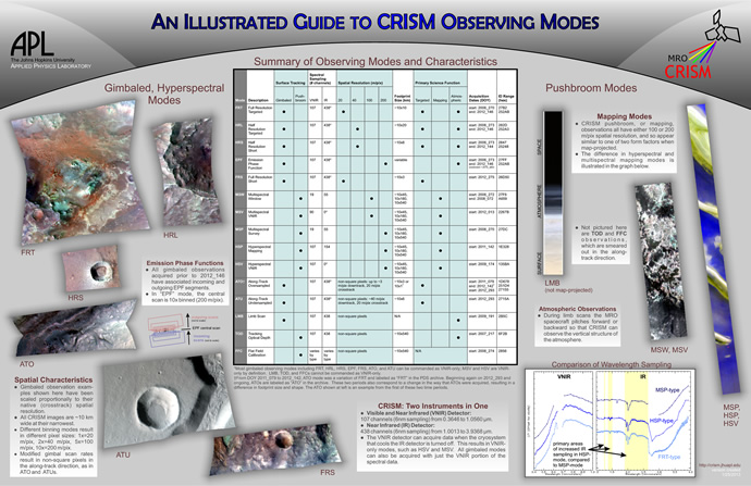
CRISM measures the martian surface and atmosphere in two ways: gimbaled and pushbroom imaging. Gimbaled observations use CRISM's gimbal to target a location and take multiple images in a sequence. Those images are then combined to produce one image of the target in question (this is much like compiling a panorama picture). Pushbroom (or mapping) observations are taken by turning CRISM on and letting the spacecraft do the pointing. As MRO flies, CRISM acquires data to take long image strips. Below is a chart showing all of CRISM's modes, how they are acquired, and their primary science functions.
CRISM uses three main methods to collect data:
- Targeted observations- The instrument's gimbal tracks a point on the surface, and superimposes a scan to cover a region approximately 10 km x 10 km (6.2 x 6.2 miles) at about 18 meters (59 feet) per pixel, in 544 wavelengths.
- Mapping observations – The instrument collects fewer wavelengths (between 72 and 262) to provide a global map of Mars at 5 to 10 times lower resolution.
- Atmospheric observations – There are several flavors of these. In one flavor, the MRO spacecraft pitches forward or backward to view Mars' limb (viewing the atmosphere edge-on) and CRISM's gimbal scans back and forth to capture the vertical structure of the atmosphere in 544 wavelengths.